Monday, June 30, 2008

Thursday, June 26 – The wettest day yet!


After the pleasant weather yesterday, we awake to drizzle and fog. We pick up our crab trap (one non-keeper) and motor back down Dean Channel. At times Tangleberry tucks in behind us as we follow radar through the fog, and at other times we follow Tangleberry through tricky Gunboat Passage, because they have a deeper keel (if they don’t hit a rock, we won’t!), and a GPS chartplotter which shows our precise location on the chart. We turn on our anchor light because we have seen a couple of very low-flying airplanes, and we want to make it easier for them to see us.

We stop briefly at Sheerwater, a fishing resort and marine repair facility, to use our cellphones, then motor across for a look at Bella Bella. It doesn’t look very inviting, so we continue on in the rain and fog to our anchorage at Kynumpt Harbour. Our canvas dodger is saturated and water is dripping into the cockpit.

When the sun comes out again, I will apply another can of waterproofing.

To avoid a wet dinghy trip between boats, we decide to raft together in the anchorage and have dinner together on Skylark. But the anchorage is just off the main channel, and when the BC Ferry, Northern Adventure, goes by, we rattle together quite violently. We fear there may be cruise ships going by overnight, so after dinner we move away and anchor on our own.


Wednesday, June 25 – Eucott Hot Springs

We wake up to clearing skies – at least enough to see the tops of the high mountains surrounding Ocean Falls. We walk a mile or so with Shirley and Grahame and friends to Martin Valley, the residential community of Ocean Falls. Several homes are maintained and lived in. At Audrey’s Greenhouse we buy some fresh lettuce and chives, and on the way back we pick beautiful bouquets of wildflowers. As we prepare to leave the dock, we realize the flowers are dropping a carpet of bugs in the boat, and we quickly donate the bouquet to the outdoor windowledge decor of The Shack.


On the advice of Grahame’s friends, we decide to detour up Dean Channel to have a soak and spend the night at Eucott Hot Springs. On the way we stop to take pictures at Alexander McKenzie Rock. A monument stands at the place he marked his arrival at the Pacific Ocean 235 years ago. Surprisingly, his inscription is still quite readable.


Eucott Bay could be set in Banff National Park, with glassy water reflecting the surrounding snow-capped mountains and glaciers, and right by the shore is an odor-free hot spring which has been roughly encased by concrete and boulders.

We sprint into our bathing suits, throw on jackets and pants because the air is still cold, and dinghy over. Two young men from Bella Coola fill us in on some local detail, then take our pictures, with our boats in the background, for their sailing charter business


brochure. As we soak in the warm water, we all agree that we have arrived!

Tuesday, June 24 – Ocean Falls

It has rained all night and we are shrouded in mist as we leave Oyster Bay. Our prawn trap is a few miles away, so we follow yesterday’s GPS track back to the spot where we dropped it. Cliff goes to it in the dinghy and starts pulling it up, only to meet with such great resistance that he yanks with full speed on the outboard. Still it doesn’t budge, so we manoeuvre the big boat over and attach the prawn trap line to the anchor windlass. With great difficulty we finally get in all 400 feet of line – and at the end, still attached, is the prawn trap, broken and squashed as flat as a pancake! Another donation to King Neptune!!

Cliff spots an Orca spouting near the mouth of the inlet, but it quickly disappears from view. Later, a school of porpoises dance and play alongside the boat.

It’s a long motoring trip up FitzHugh Sound, past what must be wonderful scenery, hidden by the clouds. Having radar to identify targets in the fog is very comforting, but all we see is a seaplane, which bursts through the clouds at almost mast height. Eventually we come into Fisher Passage and turn up Cousins Inlet to Ocean Falls. When Cliff worked for Crown Z, he often did business with Ocean Falls people, so he is naturally very keen to see the townsite.

Ocean Falls was once a thriving mill town with a population of about 5000, built in this location because of the unlimited power and water available. In 1973, Crown Zellerbach abandoned the operation. The government tried unsuccessfully to run it until 1980, when it too gave up and left the settlement to become the coast’s largest ghost town. Much of the town was bulldozed, but most of the downtown was spared and many houses were left standing, to remain as homes for the hardy 40 or so permanent residents and summer cottagers.

We arrive on typical rainy Ocean Falls day and are greeted by Sally, the friendly dockmaster, who directs us to the boaters’ shack which offers two computer stations, free wireless internet, (open 24/7 – I guess there is no thievery in O.F.), a book exchange, games, tables and chairs. We make reservations for dinner at a logging camp down the road, then kick back until suppertime.

Dinner is served cafeteria-style, and true to logging camp custom, is generous and tasty. The price of $23 includes all you can eat of salad, main course, (crab-stuffed fish, chicken, veggies and rice, )dessert, and drinks (non-alcoholic). This is the only restaurant /accommodation in town, and it serves seasonal workers, those who fly in on business, backpackers, fishermen and tourists, if any, who arrive by BC Ferry, boat , seaplane or Pacific Coastal Airlines goose.(

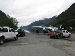
It has finally stopped raining, so after dinner we go for a walk. through the desolate downtown and along a rough road to the dam, which still supplies power to Ocean Falls, Bella Bella and Shearwater. I worry about bears on the trail, but we don’t see any. Everywhere there are masses of wildflowers, and remnants of a previous era being reclaimed by nature.


(Ph(


Monday, June 23 – Gunkholing in Fish Egg Inlet


We don’t like the weather forecast and decide to stay, but Grahame, the diehard sailor, goes looking for wind. Our plan is to meet tomorrow at Ocean Falls.

In the dinghy we go to pick up the prawn trap. With the help of the handheld GPS we finally find it. We’re getting really good at catching starfish! For the rest of the day we poke around the many bays of Fish Egg Inlet, choosing the farthest end for tonight’s anchorage. We catch a few small rockfish for crab bait, but apparently the crabs aren’t hungry.

Our anchorage in Oyster Bay has a small waterfall coming in, and bits of foam float through the bay. We are absolutely alone, miles from any civilization, and except for one commercial prawn boat, have seen no other traffic all day.

The symphony on the radio, the rush of the waterfall, and the cry of a loon provide beautiful music for an enchanted evening

Sunday, June 22 – The Dreaded Cape Caution


The water is like glass as we leave Miles Inlet. Unlike the Caribbean, this coast has so many nooks and crannies that most anchorages are absolutely calm and protected.


We encounter large, short swells from the open Pacific as we get out into the Strait. It feels like riding a rocking horse. Cliff hoists the sail to help steady the boat, and as we round Cape Caution the swells subside, allowing a superb sail for a few hours.


Our destination is Fish Egg Inlet, where we choose Green Island Anchorage. We drop the prawn trap before we enter the inlet. Hope springs eternal.


We have the anchorage to ourselves until late in the day when two more boats enter. This very photogenic spot lends itself to some artistic attempts.


Shirley and Grahame come over for dinner and beat us at Hearts again.

Saturday, June 21 – Across Queen Charlotte Strait


We have a beautiful day to cross the Strait. It’s a little foggy at first passingPultney Point Light, but later the sky clears and we have a great trip.

Back on the mainland side, we enter beautiful Miles Inlet for a quiet night.

Thursday and Friday, June 19 and 20 – Port McNeill Dock

We’ve had the luxury of three nights at the dock – electricity, heat, water, and all the conveniences of town. Port McNeill is very boater friendly, having nice restaurants, IGA, Rona, a very good Laundromat with free internet, a drug store, beauty salons, and other stores just across the street from the dock. We took full advantage and spent two busy days there.

On the advice of Grahame and Shirley, at Rona we purchased a Sirius radio and subscribed to the service for the next three months. Now in the most remote inlets we can receive, via satellite, a hundred radio channels with a wide selection of music, news, and talk shows. What a treat! We listen to CBC in the morning to hear what is happening in the world, and can even find out what the weather is in Vancouver.

Finally the jobs are done and the weather sounds favorable for crossing Queen Charlotte Strait in the morning. The sun is setting at 10:00 pm and we take a lovely sunset shot from the dock.

Wednesday, June 25, 2008

Wednesday, June 18 – Goodbye, Lagoon Cove; Hello, Alert Bay and Port McNeill

There’s lots of socializing on the dock at Lagoon Cove before the general exodus of boats following the fair weather report. We pick up our crab trap, which reveals several small female crabs, no keepers, and a supergiant starfish who obviously ate all the bait. We cast envious looks at the marina’s morning prawn catch, wishing we could stay for another afternoon happy hour. We buy a shirt, a cookbook, and a new salmon lure, pay our moorage (.75/ft., the going rate) and depart for a smooth passage across Johnstone Strait to Vancouver Island.

En route to Port McNeill, we visit Alert Bay, a charming native town on Cormorant Island. Across the street from the dock, we find a cemetery studded with totem poles looking out to the Strait.


We walk a mile in sunshine from the municipal dock to the U’mista Museum. The museum holds a fabulous display of artifacts, mainly ceremonial masks which were seized by the government during a period in the early 1900’s when potlatches were outlawed in an attempt to “civilize” the Indians. In more recent years, the carvings have been returned from museums around the world and are housed in a lovely building in this remote little village.

We see no other tourists in town today, although some of the Alaska cruise ships do make a stop here. We buy ice cream cones ($1.50) and walk back to our boats, browsing through the shops and taking advantage of photo ops along the way.


As we depart the Alert Bay Municipal Dock and take the short trip across to Port McNeill (50-36 127-05), we look forward to dinner out and a last shot at civilization before we get into the real boonies. It will be about two weeks before we see the next main town, Prince Rupert (54-15 130-11).

Friday, June 20, 2008

June 17, 2008 -- Lagoon Cove

The men are up at 0530 to listen to the weather, intending to run up Johnstone Strait before the wind comes up. The report indicates that the wind has beat us to the draw, already blowing 20 knots, so it’s back to bed with plans for a quiet day on the anchor. A new report at 10:00 indicates that it’s now calm, so we motor down Sunderland Channel and into the Strait on water smooth as glass.

After 15 miles, we’re back into the channels, where we encounter foul current (tide against us) of up to 4 knots, making it a slow trip. But Lagoon Cove (50-34 126-17), our destination for the night, is well worth the effort.

Bill Barber, owner of Lagoon Cove Marina (his “retirement project”), warmly greets us and makes space for us to raft up at the dock. This is a great marina --- friendly people, nice amenities, a generous spirit, and lots of fun. A book exchange, internet station, firepit, crab cooking shack, garbage burning barrel, unique exercise station, are all part of the deal. We attend the 5:00pm happy hour in the workshop – the marina supplies the morning catch of fresh prawns and the rest of us bring appies to share. Bill tells his hilarious bear stories and we all have a good time despite the heavy rain outside.

We are starting to see the same boats along the route and meeting cruisers, like Buffy and Dennis, energetic oldies on Kittiwake, a hot J-Class 50, and Eileen and Jerry on Lahaina, Hawaiians who leave their Sabre 50 here and come to cruise the wilderness for six months each year.

Most amusing boat name so far: Windy Spirit, with dinghy, Little Fart.

June 16, 2008 -- Forward Harbour


The scenery is beautiful, and the weather is calm, cool, and drizzly. We traverse two more sets of rapids with no problems, but since weather forecast is for gale force northwesterlies in Johnstone Strait, we pull into Forward Harbour (50-29 125-45) for the night. We raft with Tangleberry, have dinner together, and play Hearts while we listen to the downpour outside.

June 15, 2008 -- Through the Rapids


Today our timing is critical as we must go through the Yucultas Rapids at precisely slack tide, which lasts about 10 minutes. The current at maximum flow in this area runs from 10 to 14 knots. We run at 6 or 7, so there is no contest!

In 1792, the early Spanish explorers Galiano and Valdes reported in their log:

The Indians came and accompanied us (The Sutil and the Mexicana) in their canoes serving as pilots. We seized the opportune moment and were shortly beyond the most critical point, but the tide which had not stopped except for a moment, began to acquire force and reached the Sutil. It took away her steerage-way and began to carry her along . . . .then a new eddy carried her off through the canal where the currents were violent and the whirlpools frequent and so strong that one, which the Sutil could not avoid, turned her around completely three times, at such a lively rate as to be surprising. . . . In spite of the danger in which the Sutil so unexpectedly found herself, a scene never before witnessed by any of those present, it unavoidably caused great laughter, not only among those who were in danger, but among those who were momentarily expecting to be.

While waiting for the slack, we see dozens of eagles circling and picking up small fish caught in the tidal eddies. Because the depth sounder shows lots of big fish below us, we again try trolling, but still no luck!

Through the first set of rapids, we go in to the new community dock at Stuart Island (50-23 125-08). Sadly, the friendly Big Bay Resort no longer exists, but the new dock, though basic, is very pleasant.

June 14, 2008 - - Cortes Island, Desolation Sound


Tangleberry, the boat we are traveling with, is a lovely Hanse 37 with a self-tacking jib and mainsail stack pack, making it much more convenient to sail than our boat, so we motor along in light winds and take pictures while they sail.

We pass a native village and anchor in beautiful Squirrel Cove, Cortes Island (50-08 124-55). In the summer season this harbour sees dozens of boats anchored, but today there are only a few.


Cliff passes time jigging for bottom fish. We have installed a downrigger for salmon trolling and today spent a few hours learning to use it. Unfortunately we lost quite a bit of gear and caught nothing – but we did learn a few lessons!

June 12, 2008 - - Pender Harbour


Another lovely day. We enjoy motoring close to shore, admiring the beautiful waterfront real estate and wondering what it would be like to live there. Our stop for the night is Pender Harbour (49-37 124-02), where we moor at our club’s out-station dock.

We dinghy to Madiera Park for a few items of groceries I have forgotten.

We will wait here for our friends Shirley and Grahame Shannon on Tangleberry, who left home port two days behind us.

June 11, 2008 - - Leaving Vancouver


We leave our dock at Deep Cove, North Vancouver, on a dreary Wednesday morning, for a three-month cruise, hoping to go as far north as Juneau, Alaska.

Waiting for the Second Narrows railway bridge to open brings back memories of traveling on the Intra Coastal Waterway to and from our trip south in 1999 – 2006.

While fuelling up in Vancouver Harbour during busy morning rush hour, we see seaplanes zipping in and out, the seabus delivering commuters from the North Shore, cruise ships swallowing up Alaska-bound tourists, tugboats and freighters hauling loads, and yachts silently waiting in their slips for the season to summer up.


The clouds clear as we motor along the Sunshine Coast to our first anchorage at Smuggler Cove (49-31 123-58).

Roger and Carol on Heart of Gold row over to help us sterntie. We enjoy sundowners and visit with them over the next two days.

The sky is still light at 11:00 p.m. What will it be like in Alaska?

Tuesday, June 10, 2008

June 10, 2008 - - Skylark is Alaska Bound


We have spent the last three months working on Skylark to get her ready for the next big adventure. It has been almost 2 years since we arrived home in Vancouver after our 7-year Caribbean cruise, and now it is time to explore another part of the world..

We took advantage of our area’s 14-ft
tide range and put Skylark on the tide grid at our club in downtown Vancouver, changing the zincs, checking the seacocks and cutlass bearings, and determining that the bottom paint was good for another year. This saved us the cost of a haulout at the boatyard.

We did a one-week shakedown cruise to Victoria in order to ensure that all systems were go and to deliver Cliff to the 50th anniversary reunion of his Oak Bay High School class of '58. We had a great trip and felt good about the condition of the boat.

Thanks to the encouragement of our friends Juliet and David Fosh (Reflections of Hayling),who took this trip three or four years ago, kindly leaving us all their charts and guide books, we have decided to do one more relatively big cruise on Skylark. We are scheduling three months for a trip to Juneau, Alaska. We've packed lots of jeans, sweaters, sweatshirts, and foulies, but somewhere at the bottom of the pile are a couple of pairs of shorts and T shirts in case we get lucky. And we do have bathing suits on board so we can take advantage of the isolated hot springs along the way. We have also agreed that, if we don’t see the sun for weeks on end, we will happily turn, head for home, and go to Alaska some other time ..... on a cruise ship.

We will be out of cell phone range for much of the trip. We sold our Globalstar satellite phone last year and we don’t have SSB, so communication with our family and friends will be a challenge. Don’t expect that this blog will arrive on your computer on a daily basis. Since there are not many towns, the internet cafes will be few and far between.

To keep family abreast of our whereabouts, and to provide some security, we have invested in a device called “SPOT” www.findmespot.com . It is a palm-sized unit that communicates directly with a satellite and allows us to send our location (or distress signal) without depending on cell phone service. The recipient can click a link on his computer and see exactly where we are on Google Earth.

So sit back, relax, and travel along with us, NORTH TO ALASKA!